Bicycle Boulevards
Emeryville, California
Source: Pedestrian and Bicycle Information Center (PBIC)
Problem
Significant traffic growth accompanied Emeryville's rapid redevelopment from industrial to mixed use urban forms in the late 1990s. As other city streets developed into high-speed arterials, only one, a new street, carried the potential to become a north-south bicycling route without an existing base of heavy traffic. The city council supported cycling accommodations on this street, but the cycling community was divided over the best treatment.
Background
The 1998-2010 Emeryville Bicycle and Pedestrian Plan anticipated that a series of disjointed streets (Horton, Overland, and Landregan) would be connected as a condition of new development. Bike lanes were specified along much of the roadway (though the streets were too narrow for a consistent treatment). The roadway serves a variety of land uses, including light industry, artist studios, offices, street-level retail, a shopping mall, an Amtrak station, a biotechnology facility, a post office, the blank back wall of a new residential development, and the site of an abandoned paint factory — all in just 1.3 miles.
Emeryville's appointed Bicycle and Pedestrian Advisory Subcommittee includes representatives from the city council and the city's planning, public works, and police departments, as well as residents, commuters, and bike/ped advocates. Some members of this group were concerned about the bike lane plan. Traffic speed and volume could rise dramatically on a through road with bike lanes at the curb, rendering the street an automobile-dominated space unfriendly to less experienced cyclists — the very people all parties hoped would bicycle more places, more often.
Solution
The advisory committee recommended a bicycle boulevard with a shared street design rather than bike lanes along the entire length. The route became known as the "Horton/Overland Bicycle Boulevard". Preexisting bike lanes on part of the route were removed and replaced with parallel parking. Car-sized bicycle stencils were placed in the middle of each travel lane. Distinctive street and directional signage helped identify and brand the route. However, reaching a consensus on this design was not easy.

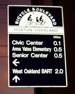
A distinctive way-finding sign directs cyclists along the Horton/Overland Bicycle Boulevard.
What is a Bicycle Boulevard?
In some ways "bicycle boulevard" is simply a fancy name for a signed bike route. A typical bicycle boulevard is a residential street with a history of low-volume and low-speed motorized traffic that has been optimized for through-travel by cyclists. Typical optimizations include overcoming connectivity gaps with bridges or cut-through paths, controlling motor traffic volume, removing stops signs from the bicycle boulevard, and adding way-finding signs. In all cases a bicycle boulevard is open to motor traffic: open streets allow cyclists to maintain high average speeds without interference from lower speed users, and to approach intersections confident that they will be seen in the normal lane positioning expected by other road users. Boulevards can be created in the center of existing built-up areas, offering direct access to destinations that no dedicated pathway can approach.
Controlling the growth of motor traffic volume is a significant design challenge. A pleasant, direct route may attract many motorists. Bicycle boulevards limit traffic by diverting motor vehicles from the street through forced right turns or restricting access with signs indicating "do not enter / except bikes."
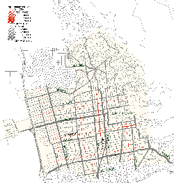
In neighboring Berkeley, Calif., the seed of the bicycle boulevard network was a 1969 traffic plan to divert cars away from residential neighborhoods. Physical vehicle barriers and forced turns preserved low traffic volume residential streets which, when linked together in 1999, formed Berkeley's bicycle boulevard network. Figure 1 shows the city's street grid. On this map, the width of the lines is proportional to the traffic volume on each street segment. The bicycle boulevard network (shown in red) approximates the spacing of the high-volume arterials to provide a similar city-wide reach. A cyclist can traverse most of the city while avoiding streets with an Average Daily Traffic (ADT) count of 5,000 or greater. Berkeley's bicycle boulevards are pleasant, reasonably direct routes without much heavy motor traffic.
Placement of bicycle boulevards depends on the available road network. In a newly built suburban development, bicycle boulevards may cut through the center of super-blocks, creating routes on long blocks that would otherwise hinder cyclists. For existing street grids where direct routes already have high traffic volumes, planners may create new links with bridges or easements, or may redirect some motorized traffic away from the bicycle boulevard. To view a video of bicycle boulevards visit http://www.streetfilms.org/archives/berkeley-bike-boulevards/or http://www.streetfilms.org/archives/portland-or-bicycle-boulevards/
The Debate among Advocates
Although the Emeryville City Council readily agreed to create a bicycle boulevard on the new route, the design details were settled only after thorough debate among cycling advocates. At issue were two competing visions of the street. In the first, cyclists used bike lanes to "own" the space; in the second, cyclists shared a designated bicycle boulevard with the rest of the community. Engineering changes would divert or calm traffic on a bicycle boulevard.

Traffic volume map, Berkeley, Calif. Red lines are bicycle boulevards; wider lines show more traffic. Image: Bryce Nesbitt
The debate focused on a handful of questions and concerns:
How will design affect traffic volume? The city council would not promise to limit future traffic growth, which forced advocates to consider how design would contribute to traffic volume. If ADT edged above 5,000 cars a day or speeds increased to 30 mph, advocates preferred bike lanes. But if speeds and volumes could be moderated, the advocates favored a shared street. They believed that bike lanes and center stripes would facilitate a fast through street for motorists, whereas a shared street would reduce the route's arterial nature and lead motorists to choose the next street over.
Who will use the route?This point recurred often in the discussion. Skilled cyclists seek the quickest and most direct route and can handle mixed traffic. Some cyclists prefer bike lanes, even when traffic passes them at 35 mph or more. Others, including novice or young cyclists, don't want to ride on any road with high traffic volumes or speeds. It helped to recognize and discuss distinct cycling preferences and skill levels, identifying specific "design cyclists" and imagining how they would make complete trips within the city.
Route consistency is important. No one will be satisfied if the route switches character every few blocks.
Vehicle parking affects bicyclists. The location and style of parking influences how people use an area and how it feels to be a cyclist or pedestrian. Certain parking styles can moderate speeds, encourage a lively pedestrian community, and support street-level retail. Parking is a key to community character and deemed integral to economic vitality.
Cycling advocates can lose sight of the big picture. Even as the shared street approach gained favor, some advocates had trouble relinquishing the bike lanes they'd gained previously; this felt like a concession to vehicular interests.

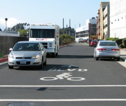
A large thermoplastic stencil with BLVD above a bicycle icon reminds motorists that they share this street with cyclists. photo: Bryce Nesbitt
Results
In the end, Emeryville's bicycle boulevard was designed as a shared street for adult cyclists who don't like heavy traffic or will trade some directness for a more pleasant route. Horton and Overland Streets are fully connected, marked, and operating as a bicycle boulevard. Parallel parking and the street's moderate congestion help to limit traffic speed and volume. (Indeed, moderate congestion can itself be a form of traffic calming.) The presence of cyclists — and the need to shift into the opposing lane to pass them — also slows traffic. The posted speed limit is 25 mph. Actual speed varies between 20 mph in narrower, more congested stretches to 30 mph on a wider section (where the original bike lanes remain and no parking is allowed due to homeland security concerns). Cyclists and motorists looking for a faster route have an alternative one block over: a four-lane arterial with 35 to 40 mph traffic and bike lanes. Motor traffic volume and speeds on the bike boulevard have increased, but only moderately. There are no diverters or barriers yet.
Not everything works smoothly. Cyclists often complain about delivery trucks parking in curbside bike lanes near the Amtrak Station. (The solution will be to provide adequate loading zones and replace the bike lanes with parallel parking.) Traffic volume will probably grow when several residential towers open; if it grows too much, the street may no longer be a pleasant place to ride without bike lanes. The city council has proposed a one-way choker which would channel traffic at certain points by creating a barrier on either side of the street. This traffic calming device is intended to reduce traffic speed and noise and may reduce volume. Finally, the Emeryville bicycle boulevard does not connect to other bicycle boulevards. The next milestone will be a link to Berkeley's network.
Other cities wanting to build bicycle boulevards may face challenges similar to Emeryville's. It may be difficult to build a complete network without compromising on some non-ideal sections. A potential core network may already exist and can be identified by polling the community to learn which low traffic volume streets cyclists presently prefer. Agencies can look for opportunities to link previously unconnected side streets and piggyback on efforts to keep pass-through motor traffic out of residential neighborhoods. Planners should be aware that fire and police departments will be concerned about plans to limit vehicle connectivity, and work to keep all stakeholders informed and involved from the beginning.
Costs
The cost to convert 1.3 miles of roadway into a bicycle boulevard totaled $30,000: $11,000 for markings, $11,000 for signage, and the balance for inspections. Design development costs were minimal because City of Berkeley design guidelines were adopted. A traffic signal, primarily to benefit motorists, cost about $250,000, plus an additional $1 million for an interlock with the railroad signaling.
Web sites and resources
http://en.wikipedia.org/wiki/Bicycle_Boulevards
http://www.ci.berkeley.ca.us/ContentDisplay.aspx?id=6650
http://www.obviously.com/berkeley/bicycle_boulevard_planning.html
http://www.streetfilms.org/archives/berkeley-bike-boulevards/
City of Berkeley CA, Bicycle Boulevard Signage Program Standards Guide V2.0, June 2003.
John Ciccarelli, UC Berkeley Institute of Transportation Studies, Bicycle Boulevards, Tech Transfer Newsletter, Fall 1999.
Oregon Department of Transportation, Bicycle Pedestrian Plan, Section II.1.E.1.
City of Napa California, Policy Guidelines: "Bicycle Boulevard", May 2005.
Joel Fajans and Melanie Curry, Why Bicyclists Hate Stop Signs, ACCESS, Spring 2001, pp. 28-31.
Bryce Nesbitt, Bicycle Boulevards: Arterial Bypass Surgery for your City?, APBP Newsletter, Summer 2005.
Contacts
Peter Shultze-Allen, Environmental Analyst
City of Emeryville
1333 Park Avenue
Emeryville, CA 94608
510-596-4300
pschultze-allen@ci.emeryville.ca.us
Bryce Nesbitt, Chair
City of Emeryville Bicycle Pedestrian Advisory Subcommittee
1712 Marin Ave
Berkeley, CA 94707
510-558-8770
bryce2@obviously.com
Image sources
Bryce Nesbitt
Figure 1 was created using City of Berkeley traffic count data.
October 2007


