Improving Pedestrian Conditions on a High Traffic Arterial
San Francisco, California
Source: Pedestrian and Bicycle Information Center (PBIC)
Problem
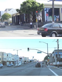
19th Avenue/Park Presidio Boulevard in San Francisco is a state-controlled, six-lane urban arterial with pedestrians, transit users, motorists and trucks mixing in a constrained right of way. Current problems with the road include low transit speeds and unreliability resulting from heavy traffic; high on-street parking demand and parking encroachment onto the sidewalk; difficult pedestrian crossings; and an unwelcoming streetscape that lacks design features suitable for a city's gateway facility.
Background
San Francisco's 19th Avenue/Park Presidio Boulevard is a major multi-use transportation corridor. Designated as California State Highway Route 1, it is an essential and heavily used north-south gateway for vehicles on the western side of the City, moving traffic toward the Golden Gate Bridge and points north. It is four miles long and has 32 signalized intersections. The highway carries more than 85,000 vehicles per day and serves high numbers of transit users. Several key bus lines operate along the corridor, serving more than 14,000 passengers per weekday, and more than 20 bus and light rail lines cross it, making 19th Avenue/Park Presidio Boulevard a major transfer location. Finally, it also functions as a major local city street, with a dense and diverse array of adjacent land uses that include single-family, multi-unit and assisted living residences, parks, local businesses, a major shopping center, schools and the San Francisco State University campus. As part of these functions, the corridor serves nearly 80,000 daily pedestrian trips and supplies much-needed on-street parking along much of its length.
Working with the community and partner agencies, four main areas of need were identified:
- Improve pedestrian safety: reduce the rate of pedestrian collisions and improve safety for the people who walk on the corridor every day.
- Improve pedestrian conditions: create a more attractive and comfortable streetscape to encourage walking, and address the problem of parking encroachment on the sidewalk.
- Improve transit operations: improve reliability and efficiency for the major bus lines that serve 19th Avenue/Park Presidio Boulevard.
- Manage and calm traffic operations: improve pedestrian and transit conditions without significantly degrading vehicular capacity.
Solution

The 19th Avenue/Park Presidio Boulevard Transportation Plan considered ways to improve travel conditions for the six-lane highway's multiple users. The goal of the plan was to improve the balance in the way the street functions for these various users. To develop a comprehensive and prioritized list of infrastructure alternatives and other actions to improve conditions in the corridor, the 19th Avenue/Park Presidio Boulevard Transportation Plan first assessed existing conditions. A literature review was conducted, which included previous multi-modal studies and surveys. Additional data were collected to assess transit ridership, operations, speed and delay; vehicle traffic volumes and delays; and pedestrian volumes and collisions. Field surveys were taken to assess conditions relating to streetscape elements and on-street parking. Finally, the plan used the San Francisco County Transportation Authority's (SFCTA) travel demand model and the Synchro traffic analysis tool to supplement information on existing conditions and analyze current needs.
A special emphasis was placed on evaluating collisions involving pedestrians. Over a five-year period, there was an average of 12 pedestrian collisions each year. The bulk of these occurred during daylight hours. Two-thirds were preceded by vehicle turning movements, split evenly between left and right turns. Fifty-seven percent of the time the driver was cited for failing to yield to the pedestrian. Of those pedestrian collisions with non-turning vehicles, most resulted from motorists running the red light or pedestrians crossing before vehicles cleared the intersection. Half of collisions with straight-through vehicles were cited as the motorists' responsibility.
Table 1: Pedestrian Collisions, 2002-2006
| 19th Ave./Park Presidio Blvd. at: | Number of Pedestrian Collisions | 19th Ave./Park Presidio Blvd. at: | Number of Pedestrian Collisions |
| Lake | 4 | Ortega | 2 |
| California | 1 | Pacheco | 1 |
| Clement | 2 | Quintara | 8 |
| Geary | 2 | Rivera | 1 |
| Anza | 2 | Santiago | 0 |
| Balboa | 2 | Taraval | 8 |
| Cabrillo | 1 | Ulloa | 1 |
| Fulton | 0 | Vicente | 1 |
| Crossover | 0 | Wawona | 0 |
| MLK Jr. | 0 | Sloat | 2 |
| Lincoln | 1 | Ocean | 1 |
| Irving | 3 | Eucalyptus | 3 |
| Judah | 3 | Winston | 4 |
| Kirkham | 0 | Buckingham (south) | 1 |
| Lawton | 2 | Holloway | 2 |
| Moraga | 0 | Crespi | 3 |
| Noriega | 4 | Junipero Serra | 1 |
| Total | 62 |

The planning process solicited substantial community input as part of the needs assessment. The SFCTA communicated information to the public via the Internet and an e-mail distribution list that grew to more than 120 citizen and community groups. In addition, two sets of community workshops were conducted in the neighborhoods surrounding the 19th Avenue/Park Presidio Boulevard, preceded by postcard mailings to residences along the corridor. The first set of workshops focused on corridor needs from the community's perspective. A common theme from this set of workshops was the need for improved pedestrian safety. The second set of workshops focused on proposed improvements for the corridor.
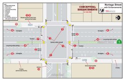
Using the results of the initial assessment, the plan identified a toolbox of improvements to address key needs. Six intersections were selected to represent the range of intersection types and conditions along the corridor. These six intersections served as the test sites for conceptual designs that deployed the toolbox of improvements. The plan presented and incorporated input on the six conceptual design prototypes from the community and partner agencies.
Table 2: Improvement Toolkit
| Toolkit Item | Improve pedestrian safety | Improve streetscape conditions | Improve transit operations | Calm traffic operations |
| ADA upgrades | ■ | ■ | ||
| New traffic signal (with pedestrian countdown) | ■ | ■ | ■ | ■ |
| Advanced limit line | ■ | |||
| New street/decorative lighting | ■ | ■ | ||
| Edge line | ■ | ■ | ||
| Special crosswalk striping/paving | ■ | ■ | ||
| Median planting | ■ | ■ | ||
| Bus bulb | ■ | ■ | ■ | ■ |
| Corner pedestrian bulb | ■ | ■ | ■ | |
| Thumbnail | ■ | ■ | ■ | |
| New transit shelter | ■ | |||
| New tree | ■ | ■ | ||
| New sidewalk | ■ | |||
| Transit boarding island | ■ | ■ |
The plan then applied the set of agreed-upon improvements from the six prototype intersections to all intersections within the corridor to obtain a comprehensive list of desired improvements. The plan also developed a list of early actions relating to education, enforcement, and engineering that could be done to improve conditions in the short term.
In summary, the plan's recommendations focused on improving conditions for multimodal travel with a strong emphasis on pedestrian safety. Proposed improvements include new traffic signals; accessibility upgrades including curb ramps; bus and pedestrian bulb-outs at intersections; an edge line stripe to define the parking lane, encourage motorists to park completely on the street, and calm traffic; median plantings; and special crosswalk treatments.
Results
Spurred by a spate of pedestrian fatalities, community groups organized to focus media attention on pedestrian safety and won vocal support from local and state elected officials to make multimodal improvements. This atmosphere prompted a high level of coordination between local and state transportation agencies and ultimately proved integral to success. The state transportation agency (Caltrans), which exercises design jurisdiction over the corridor, agreed to consider the multimodal improvements proposed in the Transportation Plan. This coordination allowed improvement ideas to move from analysis and conceptual design to funding and implementation.
To facilitate funding, speed implementation, and address the highest needs first, the corridor's intersections were prioritized into three groups, depending on the intersection's pedestrian volumes, transit ridership, vehicle traffic, and collision history.
Since the plan's adoption, the partnering agencies have been able to implement several of its recommended improvements. Local and state funding sources enabled installation of new mast arm-mounted traffic signal heads and pedestrian countdown signals, as well as ADA-compliant curb ramps, re-marked crosswalks, advance limit lines, and additional street lighting. In addition, the agencies implemented the edge line stripe, which, combined with targeted parking enforcement, reduced parking encroachment onto the sidewalk. The speed limit along the corridor has been reduced from 35 miles per hour to 30 and a double-fine zone was created to increase the incentive for safe driving.
Bus and pedestrian corner curb extensions/bulb-outs, recommended at 22 intersections along the corridor to facilitate better transit and traffic operations as well as better crossing conditions for pedestrians, are in the preliminary engineering phase.
19th Avenue/Park Presidio Boulevard is a multi-faceted transportation corridor with multiple users and functions. By using data analysis and community input, the Transportation Plan established the need to balance differing user needs with improvements to multimodal travel conditions. The Plan used a set of proven design tools for improving pedestrian and transit conditions that did not have adverse impacts on auto travel and applied those improvements selectively to intersections along the corridor based on local conditions.
Cost
The exact improvements proposed at each of the 32 intersections vary with the specific intersection's existing conditions, constraints, and needs as expressed by transit activity, pedestrian volumes, vehicular traffic, and collision history. The total estimated cost for these improvements is over $14.5 million. The overall cost estimate was developed by applying recent unit cost figures for the various toolbox items.
Table 3: Estimated Unit Costs
| Item | Unit Cost |
| Traffic signals/countdown Advanced limit lines ADA upgrades | $486,500 per intersection |
| Special crosswalk striping | $2,500 each |
| Special crosswalk paving | $10,000 each |
| Median plantings | $25 per linear feet |
| Bus bulb-out | $65,000 each |
| Corner (pedestrian) bulb-out | $40,000 each |
| Pedestrian refuge thumbnail | $15,000 each |
| Trees | $1,500 each |
| Sidewalk improvement | $25 per square foot |
| Street light | $5,000 each |
| Fire hydrant relocation | $50,000 each |
| Catch basin relocation | $50,000 each |
| Curb and gutter | $50 per linear feet |
| Transit boarding island | $150,000 each |
The edge line stripe was a separate, stand-alone project; the cost was estimated to be $75,000. Proposition K (a half-cent transportation sales tax) provides some funding for improvements in the corridor, but not enough for all identified improvements. SFCTA plans to pursue other sources of funding to leverage Prop K funds, including future regional grant programs, state programs and private and federal sources.
Web sites
More information about the 19th Avenue/Park Presidio Boulevard Transportation Plan is on the San Francisco County Transportation Authority's Web site.
The draft final report is available here
Contact
David Parisi
Parisi Associates Transportation Consulting
58 Alta Vista Avenue
Mill Valley, CA 94941-1316
(415) 388.8978
david@parisi-associates.com
Chester Fung
San Francisco County Transportation Authority
100 Van Ness Avenue, 26th Floor
San Francisco, CA 94102-5244
(415) 522-4804
chester.fung@sfcta.org


