


Regional Rail-Trail
Triangle Region, North Carolina
Source: Pedestrian and Bicycle Information Center (PBIC)
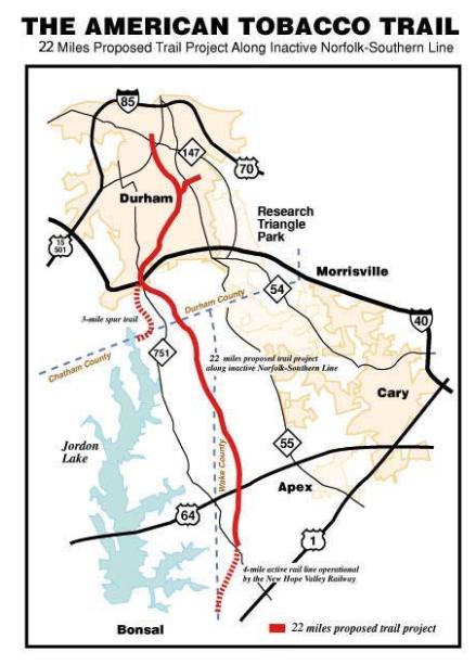
Map of the proposed trail trajectory.
Background
The American Tobacco Trail (ATT) is a 22+ mile shared-use path that begins in the City of Durham and extends through the Research Triangle region of North Carolina. Located in a former railroad right-of-way, the trail passes through three counties (Durham, Chatham, and Wake) and the municipalities of Durham, Cary, and Apex. The ATT provides bicyclists and pedestrians with unique connections and alternative routes to destinations around the Triangle.
Most of the trail began as the Durham and South Carolina railway corridor, built in the early 1900s, and abandoned in 1979. The steel and railroad ties were removed for salvage, leaving a dirt road used informally as a recreational trail by area residents.
At the encouragement of the Durham Urban Trails and Greenways Commission, the Durham City Council passed a resolution in 1987 stating that all abandoned rail corridors in the city were to be incorporated into the city's Greenway System Master Plan. The purpose of the legislation was twofold: 1) to preserve local abandoned rail corridors for potential future rail use, and 2) to promote nonmotorized recreational trail use in the corridors. The non-profit Triangle Rails-to-Trails was created two years later to promote the conversion of rail corridors to trails, and they chose the American Tobacco Trail to be their principal project.
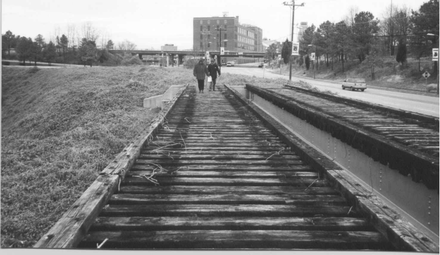
A historical picture of the former railroad tracks near what would become the trailhead of the American Tobacco Trail.
In the early 1990s, a master plan was developed for the trail and portions of the rail-trail corridor were acquired by the North Carolina Department of Transportation (NCDOT), the City of Durham, and Chatham and Wake Counties. The railroad company sold the remaining segments of the corridor to NCDOT for $2.8 million in 1995, and NCDOT leased the corridor to the counties for recreational trail development. That same year, the trail received Federal funding, which allowed planning and construction to begin in earnest.
Countermeasures
A truly cooperative effort, the trail was built in sections by the different counties and municipalities involved over a period of more than 10 years. The first section opened on the southern edge of downtown Durham in 2000 and the final section was completed in early 2014.
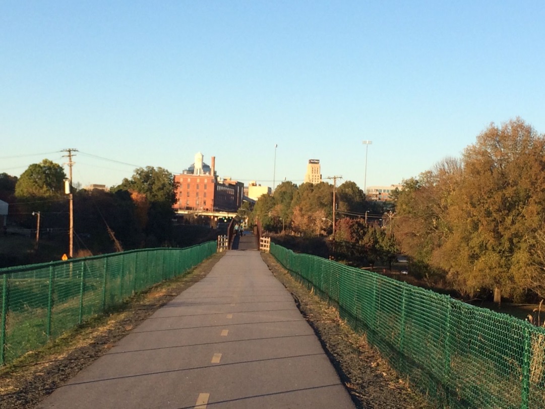
The American Tobacco Trail in 2013.
Durham was home to the first- and last-opened sections of the trail. The first 3.2-mile section of the trail, beginning at "Mile 0" in downtown Durham opened in 2000. A second, 3.2-mile segment and 1.5-mile spur opened in 2002. Construction of the trails included four bridges totaling 800 feet in length. Within City of Durham boundaries, the trail is a 10-foot-wide asphalt paved greenway with loose gravel shoulders. It is open to pedestrians, bicyclists, rollerbladers, and wheelchair users.
In Wake County, trail promotion efforts began in 1990 with official work on the trail beginning in 1998. A master plan for the Wake County portion of the trail was approved in 2000. Wake County opened its first 3.5-mile section of the American Tobacco Trail in 2003. The 10-foot-wide, granite screenings-surfaced trail was the first segment of the trail that equestrians could use, and served as a model for the rural portions of the trail in Chatham and southern Durham counties. A 1.75-mile extension to the north that included trailhead parking and restroom facilities was completed in 2005. The remaining one-mile segment was completed in 2006, bringing the total length of the American Tobacco Trail in Wake County to 6.5 miles.
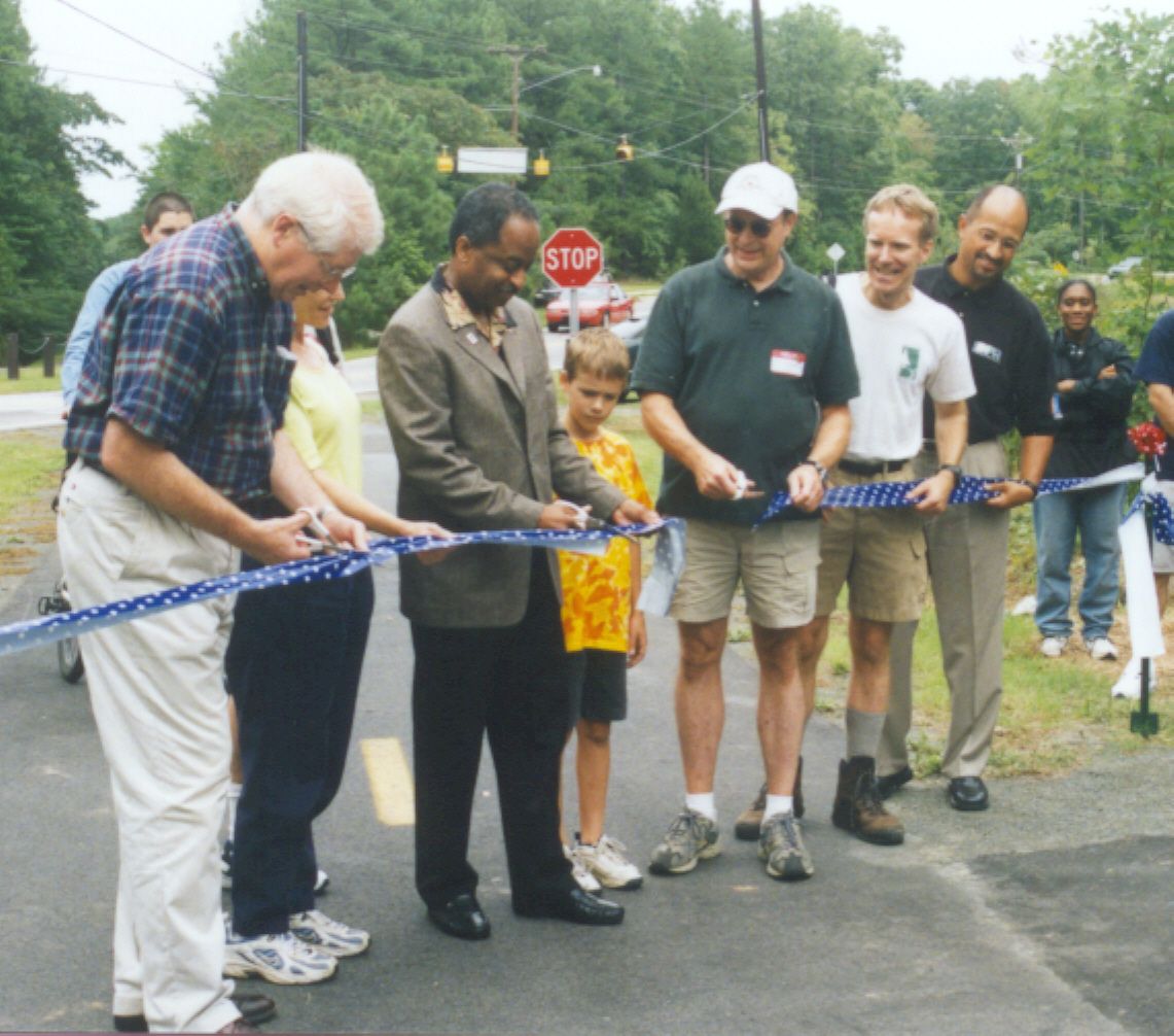
Ribbon cutting in 2002 when the second segment of the American Tobacco Trail opened.
In Chatham County, a master plan was developed and approved in 2002. The 4.7-mile trail opened in 2010. The portion of the trail that connects to Wake County to the south is a 12-foot-wide with a granite screenings surface, while the northern portion that continues into Durham County is 10-feet-wide with an asphalt surface with a 6-foot gravel screenings shoulder on one side to better accommodate horseback riding. Two wooden bridges were renovated as part of the project.
In 2014, the City of Durham completed the final, 4.2-mile segment of the trail, which connected the trail to the Chatham County segment. An important piece of this extension was a 270-foot pedestrian and bicycle bridge spanning Interstate 40, which had long served as a barrier between northern and southern portions of the trail. When the bridge opened, trail users could finally travel the entire 22-mile length of the trail from the American Tobacco complex in downtown Durham to the southwest corner of Wake County.
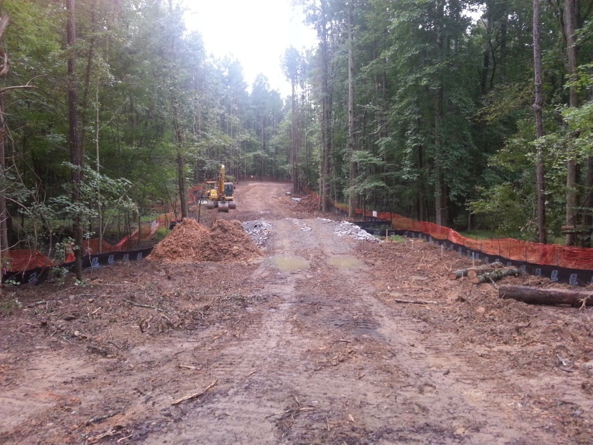
Construction of Phase E.
Where the trail crosses area roads, a number of markings and signals have been added to improve the crossings. For example, within the City of Durham, treatments include pedestrian/bicyclist-activated beacons at several intersections to alert motorists to the presence of trail users and one intersection where the crossing signal is actuated by camera. Replacement railroad bridges over busy roads provide grade-separated crossings at two locations.
Evaluation and Results
In 2007, it was estimated that the Durham and Wake County trails were each used by more than 6,000 people monthly.
TRTC continues to advocate for the American Tobacco Trail and other rail-trail and greenway projects throughout the Triangle. Nearby municipalities, such as Cary and Apex, have announced plans to build greenways that connect to the American Tobacco Trail. Future development of spur trails will eventually provide links to existing trail systems in RTP, Raleigh, Cary, and Chapel Hill/Carrboro. Once extensions are completed, the American Tobacco Trail will form the trunk of a network including over 70 miles of interconnected trails and greenways in the region.
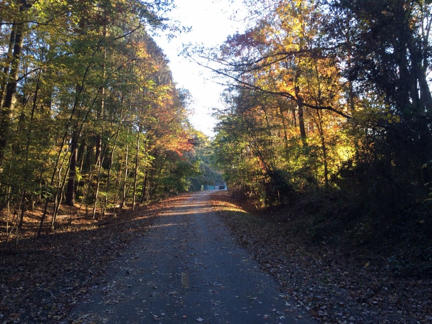
The American Tobacco Trail in 2013.
Likewise, the American Tobacco Trail is part of a much longer trail system, the East Coast Greenway, which runs along the length of the east coast from Florida to Maine. This planned, 2,600-mile long off-road greenway has been called the "Urban Appalachian Trail." The headquarters office for that trail has recently been relocated to Durham. The completion of the final ATT segment in 2014 represented a key link in the East Coast Greenway.
Dale McKeel, Durham's Bicycle and Pedestrian Coordinator, says that the trail has increased bicyclist safety by providing safer connections between neighborhoods and destinations throughout central and southern Durham. Prior to the completion of the trail, bicyclists did not have a convenient route between the residential neighborhoods to the south and the central business district. The trail, in conjunction with on-road bike lanes, also forms part of a new bicycle connection to Research Triangle Park, a major employment center.
In addition to greater connectivity, the off-road and multi-purpose nature of the trail creates broad appeal for riders with a range of interests and abilities, from experienced road cyclists and commuters to recreation-only riders or families with children. The separation from car traffic, mostly flat topography, and natural seasonal beauty make the trail the most appealing and easy-to-use bike facility in Durham. The separation from motorized traffic also reduces the risk of some crash types. Today, the ATT serves as a cycling training ground and a place to gain bicycling experience, and from there many users branch out to use on-road bicycle facilities. It is considered a tremendous catalyst for the growth of bicycling in Durham, bringing greater visibility and viability for bicycling as a mode of transportation and recreation.
Costs and Funding
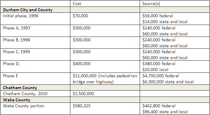
The American Tobacco Trail was made possible with not only Federal, state, and local funding, but also generous time and funding donations from volunteers and advocates. Some of the costs and funding sources associated with the ATT are listed in the table below.
References
City of Durham. American Tobacco Trail and Bridge (SW-24). 2013.http://durhamnc.gov/ich/op/pwd/consproj/Pages/SW-24-ATT.aspx
North Carolina Department of Transportation. (n.d.). Bicycle Project Highlights: Off-Road. http://www.ncdot.gov/bikeped/download/bikeped_funding_offroad_attcomplete.pdf
Rails to Trails Conservancy. Transportation Enhancements Project List 2006-2012. 2013. http://www.railstotrails.org/resources/documents/ourWork/TE_projects_by_district/northcarolina13.pdf
Town of Cary. American Tobacco Trail Chatham County. 2013. http://www.townofcary.org/Departments/Parks__Recreation___Cultural_Resources/Projects/American_Tobacco_Trail_-_Chatham_County.htm
Triangle Rails to Trails Conservancy. (n.d.) The New Hope Valley Railroad / The American Tobacco Trail. Adapted from materials prepared by Al Capehart. http://www.triangletrails.org/att/history
Triangle Rails to Trails Conservancy. (n.d.) A History of the Triangle Rails-to-Trails Conservancy. Adapted from materials prepared by Bill Bussey. http://www.triangletrails.org/about-us/our-history
Wake County. American Tobacco Trail Park Information. 2013. http://www.wakegov.com/parks/att/Pages/park_info.aspx
Contact
Dale McKeel
Bicycle and Pedestrian Coordinator
Department of Transportation
City of Durham