


The CycleTracks App and Cyclist Trip Modeling in San Francisco
San Francisco, California
Source: Pedestrian and Bicycle Information Center (PBIC)
Background
The San Francisco County Transportation Authority is the Congestion Management Agency (CMA) and long-range transportation planning entity for the City and County of San Francisco. The TA administers and oversees the delivery of the "Proposition K" half-cent local option sales tax. As such, they analyze, design, and fund improvements for roadway and public transportation. The TA also owns SF-CHAMP, San Francisco's official travel forecasting model (1).
Problem
The San Francisco County Transportation Authority (the "Authority" or TA) uses an activity-based model (SF-CHAMP) for long-range transportation planning in order to predict future travel patterns for the city. In general, modeling the bicycling mode is challenging at best and impossible at worst due to a lack of data on these travelers. The lack of data on bicyclists in most regions arises from the data collection process itself. Typically, a randomized travel survey is administered that rarely captures a sufficient amount of trips by bicycle for the purposes of modeling bicyclist behavior. The activity-based model, SF-CHAMP, had historically relied on annual or bi-annual spot location bicycle counts at 32 different intersections (2), which had enabled forecasting of the quantity of bicycle trips but not those trips distribution across the road network (3).
Solution
Apple App Screenshot
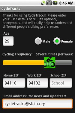
Billy Charlton, Deputy Director for Technology Services at the TA, led the development of a smartphone app for iPhone and Android, CycleTracks, that allows users to track their cycling route, distance, time traveled, trip purpose, and personal characteristics (if they so choose). CycleTracks collects these data anonymously and integrates them with current trip data for automobile and transit modes. The app development was partially funded by a Caltrans State Planning and Research Grant. Elizabeth Sall, Senior Transportation Planner with the TA, led the team that incorporated the CycleTracks data into SF-CHAMP.
From the individual's perspective, the app is downloaded and personal characteristics including age, sex, place of work, home location, and/or school zip code, and email address can be entered and saved to link with all reported trip data. After the initial setup, the user simply turns on the app and presses the button to start tracking. When finished, the cyclist can select trip purpose (e.g. work, social, etc.) and save the route. The information is then relayed to the TA's database as well as stored locally for the user to access later.
Results
Some concerns with the app include the biased sample of data it collects (smartphone-using cyclists only), a tendency of the app to misreport distance traveled, tracking initiation lags, its heavy-use of battery power, and the need for cyclists to "opt-in" and voluntarily track their trips.
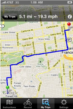
Apple App Screenshot
Despite these challenges, the current availability of cycling trip data is so sparse that this is app provides much needed information regarding a particular subset of important travelers. Charlton, along with fellow CycleTracks team members Elizabeth Sall and Jeffrey Hood, report that, "Because participation was limited to smartphone users, and because the greatest selection rate likely occurred among members of the bicycle coalitions that helped promote the application, the sample is biased. However, this drawback was outweighed by the advantages of the data collection method: reduced cost, increased rates of sampling for the small population of cyclists, and the ability to record personal characteristics and trip purposes (4)."
Over the 5-month period between November 12, 2009 and April 18, 2010, 952 of 1,083 users who downloaded the application submitted at least one trip. In all, 7,096 trips were collected. But, because the app is freely available to all iPhone and Android users, this set had to be restricted to San Francisco-based trips and non-exercise trips for the purposes of developing a bicycle route choice model, leaving 5,178 trips. Further data cleaning revealed that some of these trips were likely not made by bicycle, and in the end 3,034 bicycle trips from 366 users could be utilized (5).
The app has received 92 ratings on the Apple App Store with an average 3 out of 5 stars. The written reviews reveal frustration of the app's frequent crashing, inability to pause and resume mid-trip, and high battery use, though early reviews were generally positive. On the Android Market (6), the app gets 3.8 out of 5 stars. The written reviews are generally positive and reveal minor frustrations with the interface and unintuitive features.
With the above limitations in mind, the first 5 months' worth of bicyclist travel data produced the following conclusions: that San Francisco cyclists strongly prefer bicycle lanes to other types of bicycle facilities and disfavor climbing hills, making left turns, and deviating excessively from minimum distance paths. These conclusions were revealed by a multinomial logit bicycle route choice model, developed with the collected data, which is now fed into SF-CHAMP (7).
Android App Screenshot
These conclusions are consistent with much of the literature on bicyclists' preferences (8), however disagree with one study that suggests cyclists prefer shared-lane bicycle routes to bicycle paths (9). Hood, Sall, and Charlton (2011) suggest this is due to different methods of data collection - stated versus revealed preference - and highlight the importance of employing both methods to get complete understanding of cyclist travel behavior (10). The information gathered using the app is currently being integrated into San Francisco's regional travel model (11).
Mindful of the fact that other agencies face the same challenges for modeling cyclists' data, the TA makes the app's source code available to developers who can build upon its core functionality. It already has the functionality (12) to collect data in any locality; this means that other municipalities could quickly develop their own local version and begin collecting data on their own cycling population. In theory, the app could also be used to track pedestrian data and enhance modeling of that mode, though this use has not yet been documented.
Some communities are already using the app. In particular, Monterey, California, Eugene, Oregon and Bryan-College Station and Austin, Texas have been adapting CycleTracks for local use (13). Joan Hudson of the Texas Transportation Institute (TTI) has been leading the development in Austin. In May and June of 2011, their team promoted the app through social media, email lists, and bicycle groups and shops, and worked with the TA to gain access to the collected data. This first push garnered about 1,900 recorded trips, but only about 200 users. In the fall of 2011, they promoting the app again but through different channels: The Chronicle (a free weekly newspaper); Southwest Cycling News (published every 2 months); and Austin on Two Wheels (an online bicycle magazine). The hope is to reach a broader spectrum of the population, and while they would like to offer incentives for using the app, they are unable to do so for user privacy reasons. The research and data collection is on-going (14).
Costs
Initial development costs for the TA were under $20,000 (though this does not include staff time to promote the app or analyze the resulting data) (15). It cost only $250 to make the app ready-to-use for Austin. For the larger data collection, research, and analysis effort, they found funding through Texas A&M's University Transportation Center for Mobility ($72,000) (16), the Texas Department of Transportation ($10,000), and the City of Austin ($3,000 of in-kind services) for a total of $85,000 (17).
Other Potential Uses
This app could also be enhanced to provide encouragement measures. Similar to some other cycle trip-tracking apps, CycleTracks could provide the user with a lifetime calories burned, CO2 and gasoline saved. One of the reviewers of the app on the Apple App store mentioned a desire for web access to their personal data, complete with an elevation profile of their bicycle trip. The app might also present the individual's data in comparison with the aggregate or even with friends' data, creating friendly competition among bicyclists.
More Information
Elizabeth Sall, SFCTA Senior Transportation Planner, (415) 522-4810
Joan Hudson, Texas Transportation Institute, (512) 467-0946
Jeff Hood, Hood Transportation Consulting, (503) 477-4338
http://www.sfcta.org/cycletracks
http://tti.tamu.edu/2011/05/18/its-bike-to-work-week-study-hopes-to-improve-austin-biking/
Contact
Terra Curtis
Graduate student, Department of City and Regional Planning, University of North Carolina at Chapel Hill
tmcurtis@email.unc.edu
Notice
The Pedestrian and Bicycle Information Center, funded by the US Department of Transportation's Federal Highway Administration, does not endorse specific products or manufacturers. Trade and manufacturers' names appear in this case study only because they are considered essential to the object of the document. An attempt was made by the author to ensure that all information was balanced and factual at the time preceding publication. If you have additional information or suggestions for case study content, please contact PBIC at pbic@pedbikeinfo.org.
References
1. San Francisco County Transportation Authority. (2011). Home - San Francisco County Transportation Authority. Retrieved from http://www.sfcta.org/.
2. M Roth. (2009, Nov 12). SF Transportation Authority launches iPhone app to track cyclists." Retrieved from http://sf.streetsblog.org/2009/11/12/sf-transportation-authority-launches-iphone-app-to-track-cyclists/.
3. Charlton, B., Sall, E., Schwartz, M., & Hood, J. (2011). Bicycle route choice data collection using GPS-enabled smartphones. Transportation Research Board Annual Meeting 2011. Retrieved from http://www.sfcta.org/images/stories/IT/SFCHAMP/PDFs/bikeroutechoicedatacollection.pdf
4. Hood, J., Sall, E., & Charlton, B. (2011). A GPS-based bicycle route choice model for San Francisco, California. Transportation Letters: The International Journal of Transportation Research 3, 63-75. Retrieved from http://www.sfcta.org/images/stories/IT/SFCHAMP/PDFs/BikeRouteChoiceModel.pdf.
5. Hood, et al. (2011). pp. 64-65.
6. Android Market. (2011). CycleTracks - Android market. Retrieved from https://market.android.com/details?id=org.sfcta.cycletracks.
7. Hood, et al. (2011). p. 15.
8. Dill, J. & Carr, T. (2003). Bicycle commuting and facilities in major U.S. cities: If you build them, commuters will use them. Transportation Research Record, 1828,116-123.
9. Sener, I., Eluru, N., & Bhat, C. (2009). An analysis of bicycle route choice preferences in Texas. Transportation, 36, 511 - 539. Note: the SFCTA argues that this difference may be the result of different research methods (stated vs. revealed preference) and environmental differences between the two study areas (Hood et al., 2011).
10. Charlton, et al. (2011).
11. E. Sall, personal communication, August-September 2011.
12. San Francisco County Transportation Authority. (2010, Aug). Index of /downloads/cycletracks. Retrieved from http://www.sfcta.org/downloads/cycletracks/.
13. B. Charlton, personal communication, April 28, 2011; E. Sall, personal communication, October 5, 2011.
14. J. Hudson, personal communication, September 6, 2011.
15. Manninen, J.P. (2010, May 13). Biking to work in SF? Don't forget your CycleTracks app. Venture Beat. Retrieved from http://venturebeat.com/2010/05/13/cycletracks-helps-plan-bike-routes/.
16. Transportation Research Board. (2011). Research in progress. Retrieved from http://rip.trb.org/browse/dproject.asp?n=27815.
17. J. Hudson, personal communication, September 21, 2011.
Image Sources
Apple App Store and Android Market